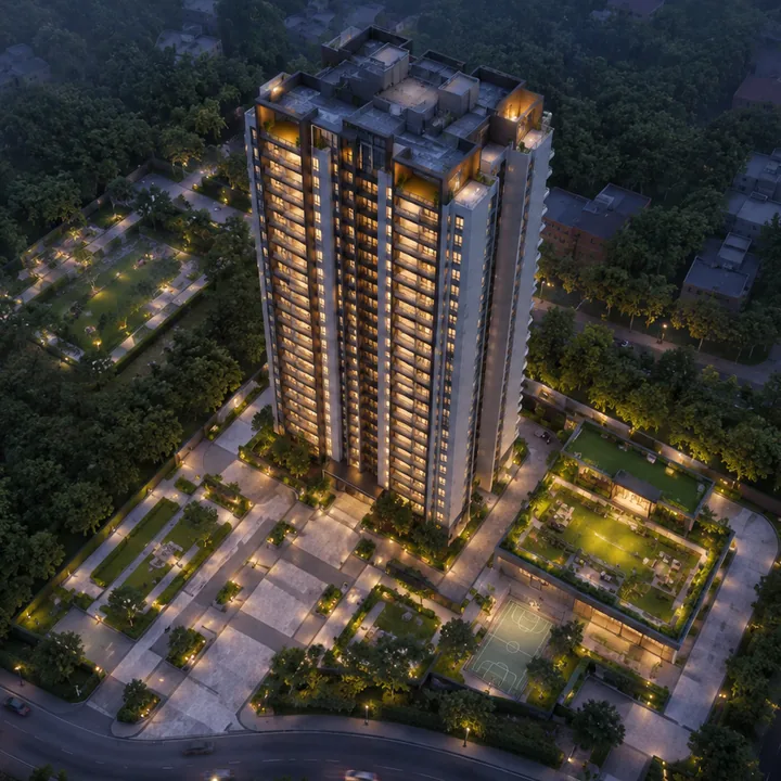
Urbanrise Begur Koppa Road Location — Begur Koppa Road, Hullahalli
The address is Begur Koppa Road, opposite Candor International School, Hullahalli, Bengaluru 560105, Karnataka, India. Urbanrise Begur Koppa Road is a development by Urbanrise, the residential brand of Alliance Group, on a 20-acre parcel that fronts this road directly across from the school. For location reading, Abhee Bellary Road keeps the context local: commute anchors, school access, hospital reach, retail convenience, and last-mile movement decide whether the address works.
The project is at pre-launch stage. K-RERA registration not yet published; the registration number will be disclosed once issued. Nothing on this page depends on that, because what follows is location research rather than project disclosure.
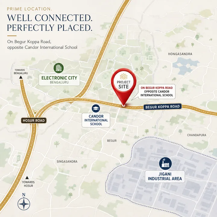
Two things about the position are confirmed and everything else on this page is measured around them: the parcel runs to 20 acres, and it sits on Begur Koppa Road, directly opposite Candor International School. The coordinates used across this site, 12.820198, 77.621627, are the school's own pin rather than the project's. "Opposite" can be several hundred metres in either direction along a road, so treat the pin as an approximate anchor; it will be replaced the moment the project's own survey details are published. Every distance below was computed as a driving route on the OpenStreetMap network from that anchor, free-flow with no traffic model, and each figure inherits the same approximation. Where a figure is a straight line rather than a route, it says so.
Urbanrise Begur Koppa Road on the map
 View on Google Maps →
Where is Begur Koppa Road in Bangalore?
Begur Koppa Road, Bangalore runs north to south through the far south of Bengaluru Urban district, from Begur at its northern end down past Hullahalli and Koppa into Anekal taluk. It is not an arterial and it does not appear on most city maps as a named route: it is the inner spine that connects the villages between Bannerghatta Road and Hosur Road, about 5 km from the first and 8 to 9 km from the second.
Urbanrise Begur Koppa Road sits on the southern half of it. Local addresses on this stretch are written Hullahalli, Begur Koppa Road, Bangalore — the Hullahalli, Begur Koppa Road node being the belt around Candor International School, roughly 7.8 km south of Begur and 1.4 km from Hullahalli village centre. The distinction between the two ends of the road matters more here than the road's name does, because the northern end is inside the city corporation and the southern end is not.
The macro position: Urbanrise Begur Koppa Road sits between two corridors, on neither
Begur Koppa Road is the inner north-south spine of the Hullahalli, Koppa and Bangipura belt in Anekal taluk. It threads between the two largest employment corridors of South Bengaluru without sitting on either: Bannerghatta Road (SH-87) about 5 km west, and Hosur Road (NH-44) with the Electronic City belt about 8 to 9 km east.
That off-arterial position is the whole thesis, and it is a trade rather than a free lunch. The site gives up highway frontage and instant name recognition. In exchange it gets a materially lower land cost, a low-rise village-edge setting, and an address anchored by two established schools on the road itself. It also means the approach roads are village roads: the kilometres are short and the minutes are not always.
The second half of the macro case is scale. Begur Koppa Road is built out in 4 to 8 acre parcels — the nearest new-build apartment scheme on the road occupies 5.67 acres — and a 20-acre parcel on this stretch is a different order of development from what the road currently carries.
The micro position: Hullahalli, Bangipura and Koppa, in Anekal taluk
| Field | Value |
|---|---|
| Locality | Hullahalli, South Bengaluru |
| Adjoining revenue villages | Bangipura and Koppa |
| Taluk | Anekal |
| District | Bengaluru Urban |
| Pin code published here | 560105 |
| Planning area context | Anekal Local Planning Area, Anekal Planning Authority (area-level context, not a sanction for this parcel) |
| Frontage road | Begur Koppa Road, roughly a 30 ft carriageway |
| Hullahalli village centre | 1.4 km |
Search for this place as Hullahalli, Bangalore, never as Hullahalli on its own. A second Hullahalli sits near Nanjangud in Mysuru district (PIN 571314), and it is the one an unqualified search resolves to first. Hullahalli, Bangalore is a revenue village on Begur Koppa Road — not a post office, and not a municipal ward.
The pin code at this end of Begur Koppa Road is 560105 — and the road genuinely changes pin
begur koppa road pin code is one of the live queries on this micro-market, and most answers to it are wrong because they assume a single road has a single delivery code. It does not.
| Pin | What India Post says it actually contains | Position |
|---|---|---|
| 560105 | Hulimangala (BO), Jigani (SO), Hennagara (BO), Haragadde (BO), Kallubalu (BO). Block: Anekal | The code published for this address. It is the Jigani and Hulimangala cluster of Anekal taluk, which is exactly the belt this parcel sits in, and it is the pin in Candor International School's own published address |
| 560083 | Bannerghatta (SO), Gottigere (SO), Sakalavara (BO), Kalkere (BO), Ragihalli (BO) | Rejected for this address. This is the Bannerghatta and Gottigere delivery area, roughly 5 km west of the frontage and across a different set of villages. It was asserted for this parcel from a reverse geocode; India Post's own office set settles it, because none of those five offices is on this road |
| 560068 | Begur (BO), Bommanahalli (SO), Madivala (SO), Singasandra (BO) | The northern belt, about 7.8 km up the road at Begur proper. A different delivery area and a different property market |
The reasoning matters more than the number. There is no post office named Hullahalli, Koppa, Bingipura or Bangipura anywhere in Bengaluru — India Post returns no record for any of them in this district — so these villages are served from a neighbouring office, and on this side that office is Hulimangala, in 560105. A landmark's own published address is the strongest documented anchor available for a frontage, and Candor International School's ends 560105. Yelenahalli and Mylasandra addresses further north on the same road sit in other delivery areas again, which is why the "what is the pin code of Begur Koppa Road" question has no single answer. It also disposes of one common error: 560105 is not an Electronic City pin. Electronic City is 560100.
If the project's own khata or survey extract later says otherwise, that document wins and this page changes. Until then, 560105.
Anekal taluk, and why the administrative line is the most important fact on this page
Three independent reads put this parcel in Anekal taluk, Bengaluru Urban district. India Post lists 560105's block as Anekal. Reverse-geocoding the anchor returns "Candor International School, Begur-Koppa Road, Bangipura, Koppa, Anekal, Bengaluru Urban, Karnataka". And an OpenStreetMap boundary query over the anchor finds no municipal-corporation polygon at all — only gram-panchayat village boundaries for Hullahalli, Koppa and Bangipura.
A note on the hobli, because the query comes up: Begur Hobli sits in Bengaluru South taluk, at the northern end of this road. This parcel is further south and the hobli covering it is not confirmed, so this site writes Anekal taluk and stops. A hobli, for anyone unfamiliar with the Karnataka system, is a revenue sub-division grouping several villages under a taluk.
The city-corporation story belongs to the other end of the road. From October 2025 the Greater Bengaluru Authority replaced BBMP with five city corporations and 369 wards, and the Begur end of Begur Koppa Road falls under Bengaluru South City Corporation. That is corridor context for the belt to the north. It is not this parcel's civic authority, and this site does not claim that it is. BBMP's own road-widening tender is titled "Widening of Begur Koppa Road (from Begur to BBMP limits)" — positive evidence that the municipal boundary runs along this very road, somewhere between Begur and Hullahalli. Exactly where, and therefore which authority sanctions a plan on this parcel, is genuinely unresolved. No approval claim of any kind is made here.
The practical consequences of a village-boundary address are real and a buyer should price them in: no corporation storm-drain or road-maintenance budget on the frontage, slower khata and building-plan processes, and a different property-tax regime from the one a buyer arriving from Bannerghatta Road or Electronic City will be used to.
The landmark: Candor International School, directly opposite
| Detail | Value |
|---|---|
| Name | Candor International School |
| Curriculum | IB PYP, MYP and DP, plus Cambridge IGCSE |
| Campus | 25 to 30 acres, residential and boarding, roughly 1,000 students |
| Opened | 2010 to 2011 |
| Distance | About 0.2 km — directly opposite |
The school is the reason this address is locatable at all. It is a 25 to 30 acre IB and Cambridge campus with boarding, established at the start of the 2010s, and it is the fixed point every direction on this page is measured from. A second established school, Christ Academy ICSE School, sits 0.9 km up the same road.
Two schools of that standing inside a kilometre is unusual for a village-edge address in South Bengaluru, and it is the single strongest non-price feature of this location. It is worth being clear about what it is not, though: proximity to a school is not admission to it, and the school's own busiest search demand is admissions and fees rather than housing.
Road connectivity from Urbanrise Begur Koppa Road
| Road | Distance and detail |
|---|---|
| Begur Koppa Road (frontage) | 0 km — the site fronts it. The belt's only continuous north-south spine: about 7.8 km north to Begur and the Hosur Road and Bommanahalli belt, 2.6 km south to Koppa village, 5.3 km south-west to Bannerghatta Main Road. Roughly a 30 ft carriageway |
| Neeladri Road | 1.7 km north along Begur Koppa Road to the junction; Electronic City's western gate 5.2 km, about 9 min in total. This, not Hosur Road, is the practical daily route east |
| Bannerghatta Main Road (SH-87) | 5.3 km, about 6 min south-west to the nearest point (2.7 km straight line); 8 to 9 km north-west to the Gottigere and Kalena Agrahara section. Widened toward 155 to 160 ft between Dairy Circle and the NICE Road junction |
| Hosur Road / NH-44 | 8.5 km, about 14 min to the Electronic City Phase 1 gate; 9.6 km to Hebbagodi; 10.6 km to Bommasandra |
| Electronic City Elevated Expressway (BETL, 9.985 km) | About 9 km to the southern ramp via Neeladri Road. This one is an estimate — the on-ramp is one-way and does not route cleanly from the site |
| NICE Road | About 8 km, about 9 min to the Bannerghatta Road and NICE Road interchange at Kalena Agrahara and Gottigere, which is the usable access point. The carriageway itself passes 4.0 km straight-line north-west, with no access there |
| Bommasandra–Jigani Link Road (BJLR) | 7.2 km, about 11 min. The shortest route to the Bommasandra KIADB estate and Narayana Health City without going via Electronic City |
| Satellite Town Ring Road (STRR / NH-948A) | Nearest alignment 10.6 km straight-line south; about 14 km, 21 min by road via Harappanahalli Road and the Jigani and Anekal side |
| Central Silk Board Junction (ORR × Hosur Road) | 13.0 km, about 18 min free-flow; realistically 45 to 70 min at peak. Koramangala 15.5 km, MG Road and the CBD 20.7 km, ORR Bellandur 19.5 km, Whitefield and ITPL 33.8 km |
The routing insight that matters day to day is Neeladri Road. From the frontage it is 1.7 km north to the junction and 5.2 km on to Electronic City's western gate, about 9 minutes in total free-flow. That approach avoids the Hosur Road service roads entirely, and it is why the eastern employment belt reads closer from here than a map of NH-44 would suggest.
The frontage road itself is the constraint. Begur Koppa Road is roughly a 30 ft carriageway. A BBMP scheme to widen it to 80 ft over 3.6 km, with Phase I costed at about Rs 42 crore, has been on the books since 2015 and was reported in October 2020 to have stalled when landowners rejected the Transfer of Development Rights offered as compensation — the scheme required roughly 750 properties, including 21,284 sq m from 257 owners. Its status has not been publicly updated since. It is a proposal, not a commitment, no completion date attaches to it, and nothing on this page treats it as upcoming infrastructure. Plan around a 30 ft road, because that is what is there.
The airport run from Urbanrise Begur Koppa Road is long
Kempegowda International Airport is 55.4 km, about 61 minutes free-flow (43.0 km straight line). Allow 1 hour 45 minutes or more at peak.
That is one of the longest airport runs of any South Bengaluru micro-market and there is no honest way to soften it. The airport sits at the far northern end of the metropolitan area and this parcel sits near the southern edge of Bengaluru Urban district; a frequent flyer should treat the address accordingly. The compensation is that almost nothing else a South Bengaluru household needs sits on the northern side.
Metro and rail near Urbanrise Begur Koppa Road
| Line | Status | Detail |
|---|---|---|
| Yellow Line (Line 4), RV Road to Bommasandra | Operational. Inaugurated 10 Aug 2025, revenue services from 11 Aug 2025. 19.15 km, 16 stations, about 35 min end to end | The working railhead for this address. Nearest stations by road: Hosa Road 7.5 km (about 13 min), Electronic City 7.6 km (about 12 min), Beratena Agrahara 8.1 km, Biocon Hebbagodi 9.1 km, Infosys Foundation Konappana Agrahara 9.5 km, Huskur Road 9.5 km, Delta Electronics Bommasandra 9.5 km. Electronic City station is 6.1 km straight line; the 7.6 km road figure reflects the dog-leg via Begur Koppa Road and Neeladri Road |
| Pink Line (Line 3), Kalena Agrahara to Nagawara | Under construction. RDSO speed trials cleared and an independent safety assessment run 5 to 6 Aug 2026, but CMRS inspection is pending and the line was not carrying passengers as of 12 August 2026 | 21.26 km, 18 stations. The elevated Kalena Agrahara to Tavarekere section (7.5 km, 6 stations) is targeted for Aug 2026 and realistically Sep 2026; the underground Dairy Circle to Nagawara section is targeted Dec 2026. The Kalena Agrahara terminus is 9.6 km, about 11 min from here — the closest terminus once it opens, and an easier drive than the Electronic City approach |
| Jayadeva Hospital interchange (Yellow × Pink) | Yellow platform operational since Aug 2025; Pink platform built, awaiting the same CMRS clearance | 13.1 km, about 17 min. The interchange that links the Hosur Road spine to the Bannerghatta spine, and the piece that makes both directions usable from this belt |
| Yellow Line extension, Bommasandra to Attibele (about 11 km) | Proposed. DPR under preparation. State permission granted, Union approval awaited. No sanction, no date | Second-order for this address: it extends the network east along Hosur Road, not toward Hullahalli |
| Proposed 73 km corridor, Kalena Agrahara to Kadugodi Tree Park via Bannerghatta, Jigani, Attibele, Sarjapur, Dommasandra Circle and Varthur Kodi, 50-plus stations, plus a 5 km spur to the Anekal stadium | Feasibility stage only. Study complete, report awaiting submission to the state. No DPR, no funding, no alignment freeze | The only alignment anywhere that would put a station within a few kilometres of Hullahalli or Jigani. DPR preparation alone takes about a year; construction earliest around 2029, then a 5 to 10 year build. A long-horizon possibility, not a project |
| Suburban Railway Corridor-4 "Kanaka Line", Heelalige to Rajanukunte, 46.2 km, 18 to 19 stations | Under construction and badly behind. L and T exited the civil works contract in Mar 2025; land acquisition and KIADB and SWR clearances are unresolved. The original Oct/Dec 2026 target is revised to June 2029 | Heelalige, the southern terminus, is 12.6 km, about 19 min east (9.7 km straight line). The cheapest north-south commuter link when it runs — post-2029, and not something to price in today |
| Indian Railways, Bengaluru–Hosur line | Operational. Carmelaram to Heelalige doubling complete; MEMU and passenger services run | Heelalige station 12.6 km (about 19 min); Anekal Road station 20.0 km (about 22 min). Low frequency, so modest current utility |
Read plainly: no metro station here is walkable, and none is close. The nearest operational station is 7.6 km by road, and there is currently no feeder bus or last-mile service running from Hullahalli to any Yellow Line station. The first leg is a car or an auto, and that is the realistic assumption for the foreseeable future.
The Yellow Line still matters, because it changed what the Electronic City drive is for. A 7.6 km run to a park-and-ride station replaces a 13 km crawl to Silk Board, and the Jayadeva interchange — once the Pink Line's platform there clears CMRS — puts both the Hosur Road and Bannerghatta spines within one change. The Pink Line's Kalena Agrahara terminus at 9.6 km is the nearest-term catalyst for this belt. It has also slipped from March to May to August and now to September 2026, which is the appropriate amount of caution to apply to it.
Employment within reach of Urbanrise Begur Koppa Road
| Centre | Distance | Note |
|---|---|---|
| Jigani Industrial Area (KIADB) | 6.7 km (about 9 min) | The closest large employment cluster by a wide margin, and the only one reachable without touching NH-44 or the Electronic City junctions. Manufacturing, engineering, pharma and ancillary rather than IT |
| 360 Business Park, Electronic City | 6.5 km (about 11 min) | The most important employment event in this catchment. TCS signed a 1.4 million sq ft lease — Towers 5A about 6.8 lakh sq ft and 5B about 7.2 lakh sq ft — worth about Rs 2,130 crore over 15 years. Phase 1 occupancy began 1 Apr 2026 and Phase 2 from 1 Aug 2026, so the headcount is arriving now |
| Wipro campus, Electronic City (Shikaripalya Road) | 7.1 km (about 11 min) | Reached via Begur Koppa Road and Neeladri Road, avoiding the Hosur Road service-road queues |
| IFIM / Jagdish Sheth School of Management and Symbiosis, Electronic City | 7.3 km (about 12 min) | Higher-education employment, and a steady faculty and student rental catchment |
| Infosys campus, Electronic City Phase 1 | 7.9 km (about 13 min) | Phase 1 is anchored by Infosys with Wipro, HCLTech, Siemens, Happiest Minds, Deutsche Bank, Genpact, Expleo and Cyient. Electronic City overall carries roughly 200 corporate campuses and on the order of 100,000 workers |
| Electronic City Phase 2 | 9.1 km (about 15 min) | TCS, Tech Mahindra, HPE, Bosch, GE, Biocon |
| Bommasandra Industrial Area (KIADB), including the Biocon bio-pharma cluster | 10.5 km (about 16 min) | Reached via the BJLR rather than through Electronic City |
| Narayana Health City, Bommasandra | 10.9 km (about 17 min) | Counted here as an employer as much as a hospital — one of the largest on the southern Hosur Road belt |
| ORR office belt, Bellandur and Sarjapur Road | 19.5 km (about 26 min free-flow, realistically 45 to 70 min at peak) | The limit of this micro-market's commute shed |
Two readings of that table are worth separating.
The first is that Jigani, not Electronic City, is the closest employment. At 6.7 km it is the only major cluster reachable without touching NH-44, and its character is manufacturing, engineering and pharma. Any household underwriting this address on IT salaries alone is missing half of what is on the doorstep.
The second is the TCS lease at 360 Business Park, 6.5 km away. A 1.4 million sq ft commitment with occupancy phasing through 2026 is a demand event with a date on it, and it lands inside the drive shed of this parcel. That is the most concrete employment fundamental this location has.
And the honest limit: if a buyer works on the Outer Ring Road at Bellandur or Sarjapur, this is not the right address for them. 19.5 km reads well and 45 to 70 minutes at peak does not.
Schools near Urbanrise Begur Koppa Road
| School | Distance |
|---|---|
| Candor International School (IB and Cambridge IGCSE, 25 to 30 acre campus, boarding, est. 2010) | About 0.2 km — directly opposite |
| Christ Academy ICSE School, Begur Koppa Road | 0.9 km (about 2 min) |
| Delhi Public School Electronic City | 3.8 km (about 7 min) |
| The Samhita Academy (CBSE), Lakshmipura | 3.9 km (about 8 min) |
| Treamis World School, Electronic City | 4.3 km (about 7 min) |
| PSBB Learning Leadership Academy, Lakshmipura | 4.9 km (about 9 min) |
| EuroSchool Electronic City | 5.4 km (about 8 min) |
| Chrysalis High, Begur | 6.3 km (about 8 min) |
| Greenwood High, Bannerghatta campus | 6.4 km (about 8 min) |
| VIBGYOR High, Bannerghatta Road | 6.5 km (about 9 min) |
| Sherwood High, Bannerghatta Road | 6.6 km (about 9 min) |
| Sarala Birla Academy (boarding), Bannerghatta Road | 8.0 km (about 9 min) |
| Ryan International School, Bannerghatta Road | 9.6 km (about 11 min) |
| Alliance University, Anekal | 19.2 km (about 20 min) |
This is the table that makes the address. Most village-edge parcels in South Bengaluru offer a state school and a long drive; this one has an IB and IGCSE campus across the road, an ICSE school within a kilometre, and a CBSE and international cluster spanning Electronic City to the east and Bannerghatta Road to the west, with fourteen options inside 10 km. The two on the road itself are the ones that remove a daily school run from the household calculation altogether.
Hospitals near Urbanrise Begur Koppa Road
| Hospital | Distance |
|---|---|
| Indira Hospital, Jigani and Bannerghatta side (nearest general hospital) | 4.6 km (about 6 min) |
| Kauvery Hospital, Electronic City | 7.6 km (about 13 min) |
| Apollo Cradle and Children's Hospital, Electronic City | 8.3 km (about 14 min) |
| Narayana Nethralaya, Bannerghatta Road | 8.7 km (about 12 min) |
| Fortis Hospital, Bannerghatta Road (multi-speciality, quaternary) | 10.6 km (about 14 min free-flow) |
| Vimalaya Hospital, Hebbagodi | 10.6 km (about 16 min) |
| Narayana Health City / Mazumdar Shaw Medical Centre, Bommasandra | 10.9 km (about 17 min) |
| Apollo Hospitals, Bannerghatta Road | 11.0 km (about 14 min) |
| SPARSH Hospital, Bommasandra | 11.5 km (about 17 min) |
| Sri Jayadeva Institute of Cardiovascular Sciences, Jayanagar 9th Block | 13.1 km (about 17 min free-flow) |
The nearest general hospital is 4.6 km. The nearest quaternary care — Fortis and Apollo on Bannerghatta Road, Narayana Health City and SPARSH at Bommasandra — is 10.6 to 11.5 km, in three different directions. Those free-flow figures are the ones to be sceptical of in an emergency, because the first two kilometres of every one of them run on the 30 ft frontage road.
Retail, hospitality and daily needs
| Destination | Distance |
|---|---|
| Mango Mist Resort (Bannerghatta and Koppa side) | 4.9 km (about 7 min) |
| The Oterra, Electronic City (nearest banqueting) | 6.9 km (about 12 min) |
| Electronic City hotel cluster — Golden Tulip, Radha Regent, Svenska, Lords Plaza | 7 to 8 km (about 12 to 14 min) |
| DMart, Gottigere (nearest large-format grocery) | 8.2 km (about 9 min) |
| Royal Meenakshi Mall, Hulimavu | 8.8 km (about 12 min) |
| M5 Ecity Mall, Electronic City | 9.6 km (about 16 min) |
| Lulu Hypermarket, Electronic City | 9.7 km (about 16 min) |
| Bannerghatta Biological Park | 10.5 km (about 13 min) |
| Nexus Vega City, Bannerghatta Road | 12.8 km (about 16 min) |
| Gopalan Innovation Mall, JP Nagar | 12.9 km (about 16 min) |
This is the weakest table on the page and it should be read that way. The nearest large-format grocery is 8.2 km and the nearest malls are 8.8 and 9.6 km. Day-to-day retail at this address means local kirana and the convenience provision a township of this size would need to build for itself. A household without a car will find the location hard work; a household with one will make an 8 to 10 km weekend run a routine.
The infrastructure pipeline, with its real status
| Item | Status | What it actually means here |
|---|---|---|
| Pink Line elevated section | Under construction, CMRS clearance pending, targeted Sep 2026 | Puts a metro terminus 9.6 km west. The nearest-term catalyst and the only one likely to land within a year. It has already slipped from Mar to May to Aug to Sep 2026 |
| Proposed 73 km Kalena Agrahara to Kadugodi corridor | Feasibility study only | Genuinely transformative if built, because it is the one alignment that would bring a station near Hullahalli. A decade-out option, not a purchase justification |
| Yellow Line, Bommasandra to Attibele | DPR stage | Realistically post-2029, and second-order for this address in any case |
| STRR / NH-948A | Partly operational — four of six packages complete; Hoskote to the Tamil Nadu border targeted June 2026, the remaining packages Sep and Nov 2026, full network 2027 | Runs about 14 km south by road. Its real value here is pulling Chennai-bound freight off NH-44 |
| Kanaka Line (Suburban Corridor-4) | Under construction, revised to June 2029 after L and T exited | Heelalige terminus 12.6 km. Do not price it in |
| NH-44 junction upgrade programme | In progress — four grade separators and underpasses, plus service roads widened to three lanes each side | Short-term this makes the eastern route worse through 2026; a carriageway cave-in near Attibele in Feb 2026 shut lanes for hours. Medium-term it delivers a closer-to-signal-free run south |
| Anekal international cricket stadium | Cabinet in-principle approval Oct 2025; KHB has tendered Phase 1 (Rs 950 crore) of a Rs 2,350 crore, 80,000-seat project on 75 acres at Suryanagar 4th Stage Extension, Indlavadi village | About 17.5 km south. The significance here is fiscal rather than recreational — it pulls state road and utility spend into Anekal taluk. Phase 1 roughly 2029 |
| Begur Koppa Road widening | Proposed since 2015, reported stalled in October 2020 when landowners rejected the TDR offer; no public update since | Not committed infrastructure and not dated. Treated on this site as a proposal only |
| Cauvery Water Supply Stage V | Rs 4,336 crore, JICA-funded, +775 MLD, commissioned Oct 2024 — but scoped to 110 villages inside BBMP limits | Hullahalli, Koppa and Bangipura are outside that boundary. This scheme does not reach this site. See the trade-offs below |
The pattern across that table is worth naming, because it is the corridor's real risk profile: every item is genuine, and not one has a reliable date. The Pink Line has slipped four times. The Kanaka Line moved from 2026 to 2029. The STRR's final packages slipped about 16 months. The stadium has in-principle approval and a three-year build ahead of it. A location thesis built on any single one of them is a bet on a delivery record that this corridor does not have.
The trade-offs at this address
These belong in the copy, not hidden from it.
- This is not a corporation address. Reverse geocoding returns "Bangipura, Koppa, Anekal, Bengaluru Urban" and a boundary query finds only gram-panchayat village polygons. That means no corporation storm-drain or road-maintenance budget, slower khata and building-plan processes, and a different property-tax regime. Buyers arriving from Bannerghatta Road or Electronic City proper will assume corporation-grade civic services and will not get them.
- Water is the hardest constraint here and cannot be waved away. The Central Ground Water Board classifies Anekal, like every Bengaluru Urban assessment unit, as over-exploited. Groundwater in the taluk has fallen roughly 7.4 to 9 metres, and in drought years 26 villages in the taluk have been entirely tanker-dependent, with Jigani and Bommasandra named among the worst affected. Cauvery Stage V does not reach this boundary. Honest underwriting at this address assumes tanker contracts, on-site sewage treatment with treated-water reuse, and rainwater harvesting — not as amenities but as operating necessities.
- The frontage road is the bottleneck and its fix has been stalled for a decade. Roughly 30 ft of carriageway, an 80 ft proposal on the books since 2015, and a stall reported in October 2020.
- No metro within walking distance, and the nearest one points away from the site. 7.6 km by road to Electronic City station, with no feeder service. The Pink Line helps in the other direction from late 2026 at the earliest. The one corridor that would put a station near Hullahalli has a feasibility study and nothing else.
- Employment is close in kilometres but not always in minutes, and the pipeline is currently making it worse. The western approach routes funnel through two-lane village junctions that saturate at school-run and shift-change hours, while NHAI works disrupt the eastern route through 2026.
- Social infrastructure is thin beyond the two schools on the road itself. Nearest large-format grocery 8.2 km, nearest malls 8.8 and 9.6 km, nearest quaternary hospitals 10.6 to 11.5 km.
- The corridor's forward story rests on projects with a poor delivery record. Every item in the pipeline table is real; not one is bankable on the timeline currently marketed in this belt.
The investment case for the Urbanrise Begur Koppa Road location
What the location is actually buying is a price gap that has a reason for existing and a set of reasons it might close.
Urbanrise has not published a price for this project. Apartment-class homes in the Hullahalli and Bingipura node of Begur Koppa Road currently sit in an indicative band of Rs 5,400 to Rs 6,800 per sq ft, and it is that micro-market band — not a project rate — that every figure on this site is derived from. Five to eight kilometres north, at Begur Road proper inside the corporation, mid-tier stock runs about Rs 6,700 to Rs 9,500 per sq ft and peaks at Rs 12,000 to Rs 14,000 for the largest branded launch. Those are two different markets on one long road and this page does not blend them. The widely quoted locality figure of about Rs 10,250 per sq ft for "Begur Road" is an aggregator asking-price index dragged up by two premium launches at the far north end, and it does not describe this node — the Rs 4,569 floor of its own published range is nearer this node's reality than its mean. The full derivation, and the named on-road benchmark it rests on, is set out on the price page.
The corridor's performance is documented and comes with two caveats that must travel with it. The Begur Road asking-price index is up 19.9% over one year and 72.3% over five; adjacent Bommasandra, which is the better proxy for this pin because it is the neighbouring Anekal-taluk node, is up 17.1% over one year, 97.3% over five and 121.5% over ten. Caveat one: those are ask indices, not transaction indices, and they must never be annualised forward or read as realised return. Caveat two, and it is the calibration every number in this belt needs — in Bommasandra the average ask of about Rs 7,200 per sq ft sits against an average recorded transaction of Rs 5,273 per sq ft, a 27% gap. Apply that haircut to every aggregator figure quoted anywhere on this corridor, including the ones above.
On that basis the derived expectation for the Hullahalli and Koppa node is a base case of 8 to 12% compound growth over five years — faster in percentage terms than Begur Road proper is likely to sustain, because this node starts from a much lower absolute base with genuine catch-up room as the Yellow and Pink Lines pull the southern arc up. It starts lower for reasons that will not vanish quickly, though: Anekal taluk rather than the corporation core, no metro within about 6 km, and thin social infrastructure. That figure is an inference from corridor comparables, not a forecast anyone has underwritten.
As a rental catchment the location is real but modest. Electronic City, 6.5 to 9 km east, quotes 2 BHK rents of Rs 25,000 to Rs 55,000 a month in 2026 at 92 to 96% occupancy, and Begur Road proper to the north runs Rs 18,000 to Rs 32,000 for a 2 BHK. Applying the same 15 to 25% discount visible in the sale-rate gradient gives an inferred Rs 15,000 to Rs 22,000 a month for a 2 BHK at this pin and Rs 21,000 to Rs 30,000 for a 3 BHK. That supports a low-single-digit gross yield at inferred launch pricing, which makes this an end-user-led, hold-to-completion case rather than a day-one rental play. The arithmetic is on the price page.
The location-specific things that would actually move the case are, in order of realism: the Pink Line terminus opening 9.6 km west; the TCS headcount at 360 Business Park, 6.5 km away, arriving through 2026 and 2027 on a lease that is already signed; state spend flowing into Anekal taluk behind the stadium and the STRR; and — only in the last decade of that list — the proposed Kalena Agrahara to Kadugodi corridor, if it is ever built. The things that would break it are the frontage road staying 30 ft, water provisioning being under-designed, and the buyer discovering after purchase that a gram-panchayat address does not deliver corporation services.
What is still unknown about this location
An honest location page has to say what it does not know.
- The project's own pin and survey numbers. Everything positional on this page hangs off Candor International School's coordinates. "Opposite" is not a survey boundary.
- Which side of the municipal line the parcel falls on, and therefore which authority sanctions a plan here. BBMP's own tender wording puts the boundary somewhere along this road between Begur and Hullahalli; where exactly is not published.
- Whether the Begur Koppa Road widening has moved at all since October 2020. No public update has been located.
- Whether BDA's PRR-2 layout programme covers this Hullahalli. The programme — about 6,217 acres across 22 villages between Hosur Road and Mysore Road, approved August 2025 — reportedly includes a village called Hullahalli, but Hullahalli is a common Karnataka toponym and it could not be confirmed that the listed village is this one. It is simultaneously a possible upside and a possible land-acquisition overhang, and this site asserts it in neither direction.
- The hobli covering this parcel, which is why this page writes Anekal taluk and stops there.
Each of these is checked again when a primary document arrives, and this page is updated rather than quietly left standing.
Urbanrise Begur Koppa Road Location — frequently asked questions
Next step for Urbanrise Begur Koppa Road
Two things about this project are confirmed: 20 acres, and the address opposite Candor International School. Register and you will get the unit mix, the price list and the K-RERA number as each one is published.